Maps Timeline
approvedby Arseniy Seroka
View your Google Maps Timeline location history on an interactive map — visits, routes and exact GPS tracks, with day and date-range pickers. - This plugin has not been manually reviewed by Obsidian staff.
Maps Timeline
View your Google Maps Timeline (location history) on an interactive map inside Obsidian — visits, movement routes, and your exact GPS tracks — with day, month and custom date‑range pickers. Your data never leaves your machine; map tiles come from OpenStreetMap or Esri (no key) or Google (your own key).
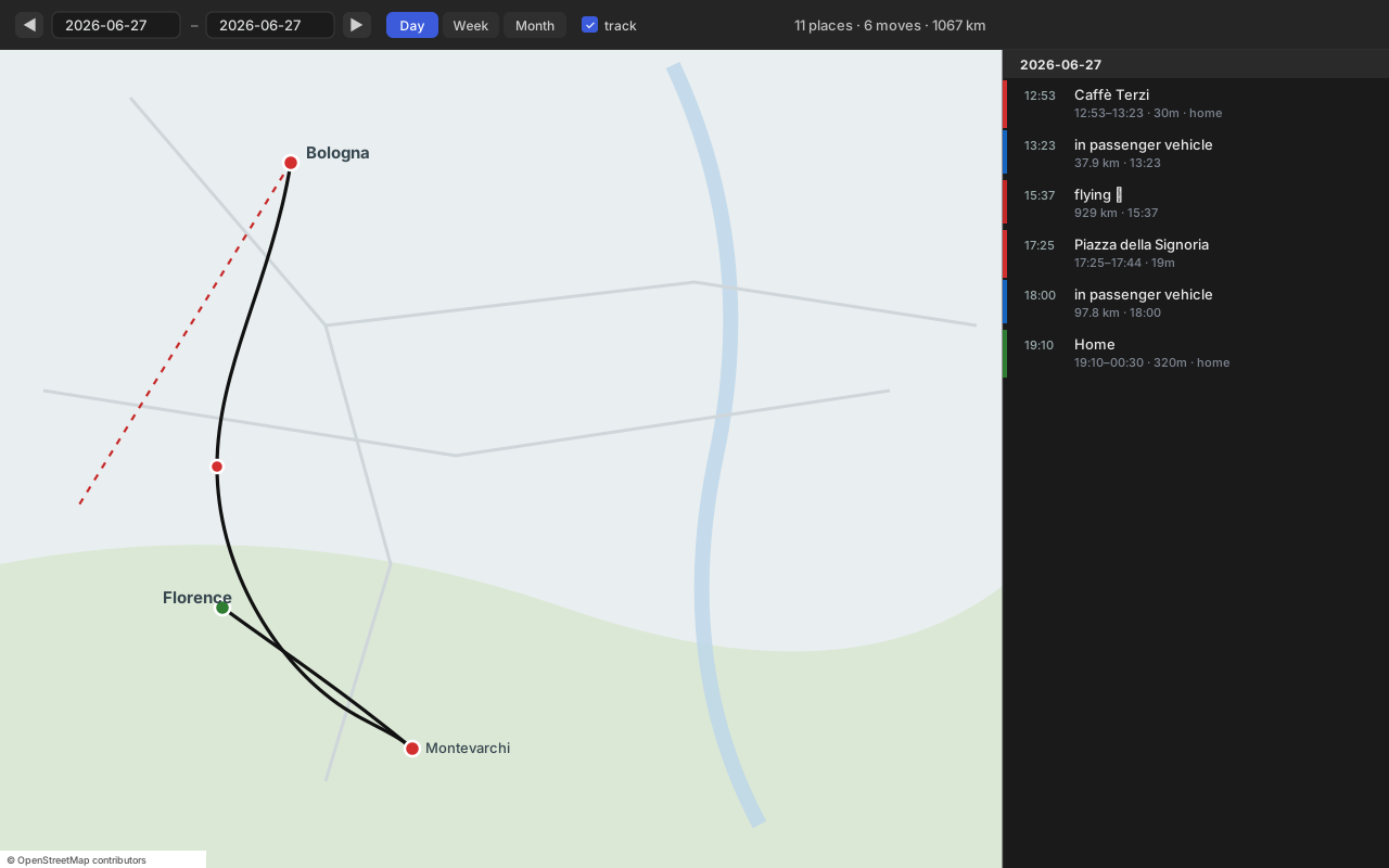
A two‑pane view: an interactive map on the left, a clickable timeline of that period on the right. Click any row to fly the map to it.
Features
- 🗺️ Interactive map of your location history — opens as its own pane, not a note.
- 📍 Visits as dots: 🟢 home · 🟣 work · 🔴 other. Click for name, time and duration.
- 🛣️ Real routes — your dense, road‑following GPS track (not a straight line between stops).
- ✈️ Flights drawn as a dashed line (because flights really are straight).
- 🗓️ Pickers — single day,
◀ ▶stepping, Day / Week / Month quick buttons, or a customfrom–torange. - 🧭 Timeline sidebar — every visit and move for the period, grouped by day; click to focus on the map.
- 🏷️ Place names on demand — resolves coordinate‑only visits (Google's newer on‑device export has no names) via the Places API, cached locally so each place is fetched only once.
- 🌍 Basemaps — OpenStreetMap or Esri Satellite (free, no key), or Google Roadmap / Satellite / Hybrid / Terrain via your own key (Map Tiles API).
- ⚡ Canvas rendering — handles months of dense data without freezing.
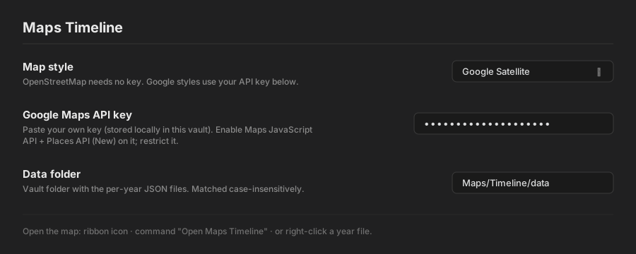
| Settings |
|---|
 |
Install
Manually
- Download
main.js,manifest.json,styles.cssfrom the latest release. - Copy them into
<your-vault>/.obsidian/plugins/maps-timeline/. - Settings → Community plugins → Maps Timeline → enable.
Via BRAT
Add jagajaga/obsidian-maps-timeline in the BRAT plugin.
Get your data
The plugin reads per‑year JSON files in a vault folder (default Maps/Timeline/data/). Generate them from your Google data once:
- Export your timeline:
- Takeout (history up to 2024): takeout.google.com → deselect all → Location History (Timeline) → export.
- On‑device (recent months): Google Maps app → profile → Settings → Location & privacy / Timeline → Export Timeline data →
Timeline.json.
- Convert with the scripts in
tools/(see tools/README.md):pip install ijson MAPS_TAKEOUT=/path/to/export MAPS_OUT=/your-vault/Maps/Timeline/data python3 tools/maps_days.py MAPS_TAKEOUT=/path/to/export MAPS_OUT=/your-vault/Maps/Timeline/data python3 tools/maps_tracks.py - Point the plugin's Data folder setting at that folder.
The data format is simple — any converter producing the same shape works.
Usage
Open the map three ways: right‑click a year file (…/2018.json) → Open in Maps Timeline, the 🗺 ribbon icon, or the command Open Maps Timeline. Then pick a day, step with ◀ ▶, jump with Day / Week / Month, or type a custom range. Toggle the dense track layer off for very large ranges.
Settings
| Setting | What it does |
|---|---|
| Map style | OpenStreetMap or Esri Satellite (no key), or a Google basemap (needs key). |
| Google Maps API key | Your own key, stored locally in the vault. Enable Map Tiles API (Google tiles) and Places API (New) (place names). Restrict it. |
| Data folder | Vault folder holding the per‑year JSON. Matched case‑insensitively. |
Data format
Each <year>.json is { "year": 2018, "days": { "YYYY-MM-DD": Day } }, where a Day is:
{
  "source": "old",
  "visits": [
    { "placeId": "ChIJ…", "name": "Caffè Terzi", "lat": 44.49, "lng": 11.34,
      "start": "2018-08-01T12:53:00Z", "end": "…", "minutes": 30, "semanticType": "TYPE_HOME" }
  ],
  "activities": [
    { "type": "IN_PASSENGER_VEHICLE", "km": 37.9, "start": [44.5,11.3], "end": [43.8,11.2],
      "startTime": "…", "path": [[lat,lng], …] }
  ],
  "paths": [ { "startTime": "…", "path": [[lat,lng], …] } ],
  "track": [ [lat,lng], … ]
}
name may be null for coordinate‑only visits — the plugin fills those in via the Places API and caches them.
Privacy
- Your location data lives only in your vault — the plugin never sends it anywhere.
- Your Google API key is stored locally and used only for Google tiles and Places‑name lookups, called directly from your client.
- OpenStreetMap / Esri Satellite modes use no key and make no Google calls.
Building
git clone https://github.com/jagajaga/obsidian-maps-timeline
cd obsidian-maps-timeline
npm install
npm run build      # bundles src/main.js + Leaflet -> main.js, and styles.css
Source lives in src/; main.js and styles.css are bundled outputs. Releases are built and attested by GitHub Actions (.github/workflows/release.yml).
Credits
- Leaflet (BSD‑2) — bundled map engine.
- Tiles: © OpenStreetMap contributors · © Esri · © Google (Map Tiles API).
- Interaction design inspired by kurupted/google-maps-timeline-viewer.
License
MIT. Bundled Leaflet retains its BSD‑2 license (see NOTICE).
For plugin developers
Search results and similarity scores are powered by semantic analysis of your plugin's README. If your plugin isn't appearing for searches you'd expect, try updating your README to clearly describe your plugin's purpose, features, and use cases.