Advanced Maps
approvedby Jin1c
Turn Obsidian's native Maps into a photo atlas and route viewer: map whole geotagged albums, GPX/GeoJSON/KML/TCX tracks, and Around views of linked notes. - This plugin has not been manually reviewed by Obsidian staff.
Advanced Maps


English · 简体中文 · User guide (in this repository)
Turn Obsidian's native Maps view into a photo atlas, a route viewer, and a map of the notes connected to the one you are reading.
Advanced Maps reads GPS from whole photo folders, draws GPX/GeoJSON/KML/TCX routes and areas, and creates an Around view from ordinary Obsidian links. It extends the first-party Maps view instead of replacing it: MapLibre, backgrounds, markers, popups, and every built-in map option remain native. No Leaflet, no bundled renderer, no runtime dependencies.
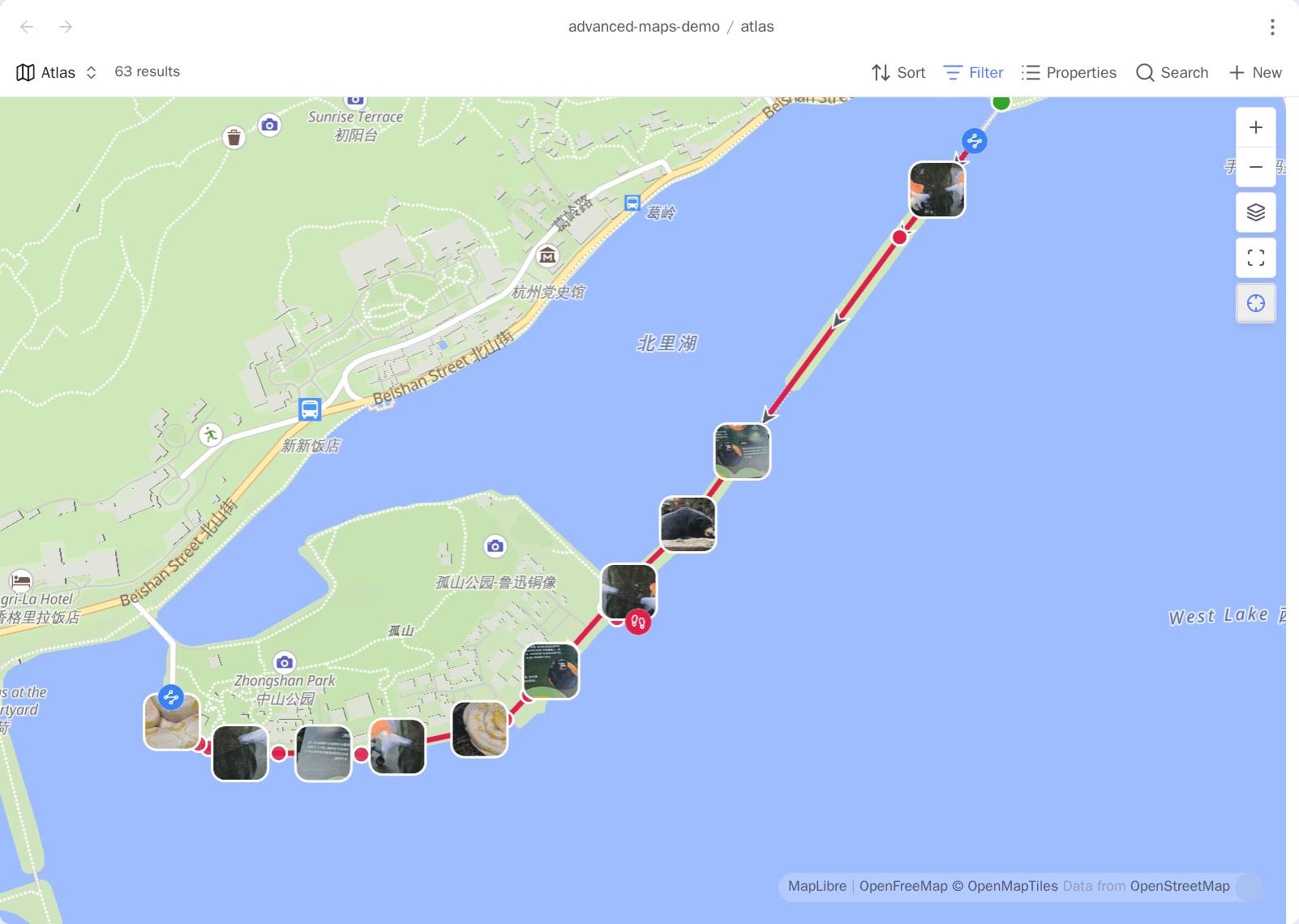
One Base, one map: the pins are place notes coloured by a Base formula,
thumbnails are photos placed by their own EXIF, and the line is a .gpx a note
links to. 63 results.
Three workflows
| Use Advanced Maps as… | Put this in the Base | What appears |
|---|---|---|
| A map photo album | A photo folder, including a link to an external album | Every photo with readable GPS, at its EXIF location |
| A route viewer | Notes linked to .gpx, .geojson, .kml, or .tcx files—or those files alone | Routes, areas, markers, photos, elevation, and statistics a Base can sort on |
| An Around map | Your place-note collection | The current note, its links and backlinks, plus their tracks and photos |
These compose. One map can show place notes, a multi-day route, and every geotagged photo taken along it.
Advanced Maps and Map View
Map View is the other map plugin for Obsidian, and it is a whole GIS: its own map view, its own query language, display rules, an edit mode, routing, and a Bases view of its own. Advanced Maps is a different shape. It has no map view of its own at all — it adds to the one the Obsidian developers ship with Bases, and it bundles no renderer.
Map View's own comparison with the native Maps view is a fair one, and the column it marks unsupported is the clearest description of what this plugin is for:
| Native Maps on its own | With Advanced Maps |
|---|---|
| No paths | GPX, GeoJSON, KML and TCX, linked from a note or mapped as files, with areas, direction arrows, elevation profiles and statistics |
| No geocoding | Place search and reverse geocoding, through OpenStreetMap or Amap |
| Display only | Coordinates entered from the map, a pasted map link, a photo's EXIF, a search result, or the device's own position |
| No offline usage | A folder of tiles already on disk as the background of every map, with no request leaving the machine |
Markers stay native throughout, which is the whole point of extending rather than replacing: Bases formulas still decide their icon and colour, filters still work, and every built-in view option is still there.
Map View is the better choice if you want several locations in one note,
inline geolocations in the body text, marker display rules, built-in routing, or
a map that does not need Bases at all. Advanced Maps does none of those, and
ROADMAP.md records which of them are deliberate non-goals and why.
Both read a lat,lng coordinate from front matter, so one property can feed
either.
Requirements and install
Advanced Maps requires Obsidian 1.13.1 or newer with Bases enabled and the first-party Maps plugin installed. Without that native view, it reports or skips the unavailable enhancement and leaves Obsidian usable.
Install it from inside Obsidian: open Settings → Community plugins, turn off
Restricted mode if it is on, select Browse, search for Advanced Maps,
then Install and Enable. The store listing is
community.obsidian.md/plugins/advanced-maps.
For a build the store does not have yet, copy main.js, manifest.json, and
styles.css from Releases into
<vault>/.obsidian/plugins/advanced-maps/, or add
Jin1c-3/obsidian-advanced-maps in BRAT.
Quick start
Save this as atlas.base, replace the folder paths, open it, and choose its map
view:
filters:
  or:
    - file.inFolder("places")
    - file.inFolder("assets/onedrive/Pictures")
views:
  - type: map
    name: Atlas
    coordinates: coords
    trackWeight: 4
    trackOpacity: 85
    fitMaxZoom: 16
The first branch maps notes whose coords property holds a coordinate. The
second maps supported photos directly from their GPS metadata. See
Getting started for the Base boundary, view
keys, supported photos, and the next recipes.
User guide
| Topic | Covers |
|---|---|
| Getting started | Installation, Base boundaries, first map, view keys |
| Photo maps | Photo folders, OneDrive, linked photos, thumbnails, index |
| Tracks and areas | Route links, inline maps, GPX/GeoJSON/KML/TCX, polygons, statistics as properties |
| Around and navigation | Around views, reusable Base, Open in map, follow, measuring, shared pins |
| Places in and out | Importing a file of placemarks as notes, exporting a Base as GPX/KML/CSV |
| Offline basemap | Named tile packs already on disk, picked from the map, with their own zoom bounds |
| Coordinates and services | WGS-84/GCJ-02/BD-09, external maps, search, geocoding, location |
| Reference and privacy | Supported inputs, option ownership, operational limits, network disclosure |
Notes, tracks, and photo contents do not leave on their own. The plugin has no telemetry, update ping, or server; the privacy reference lists the requests made when you use maps or external services.
Project documentation
- CONTRIBUTING.md: setup, testing, pull requests, and releases.
- OpenSpec capabilities: stable technical contracts.
- CHANGELOG.md: released behavior.
- ROADMAP.md: possible future work and deliberate non-goals.
Licence
MIT.
For plugin developers
Search results and similarity scores are powered by semantic analysis of your plugin's README. If your plugin isn't appearing for searches you'd expect, try updating your README to clearly describe your plugin's purpose, features, and use cases.