Spherical Graph
approvedby Pavel
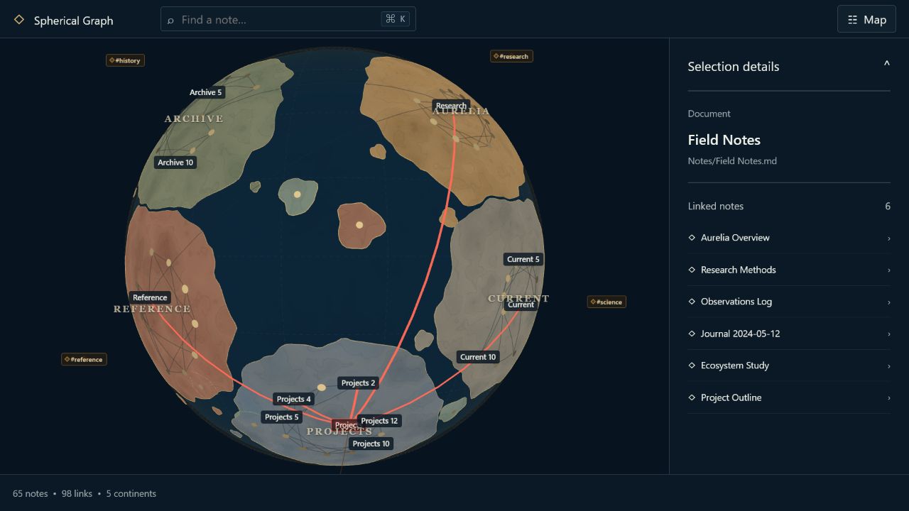
Explore your vault as a living globe: folders become continents, notes become cities, links become roads, tags orbit as satellites, and Route Finder reveals paths between ideas. - This plugin has not been manually reviewed by Obsidian staff.
Spherical Graph


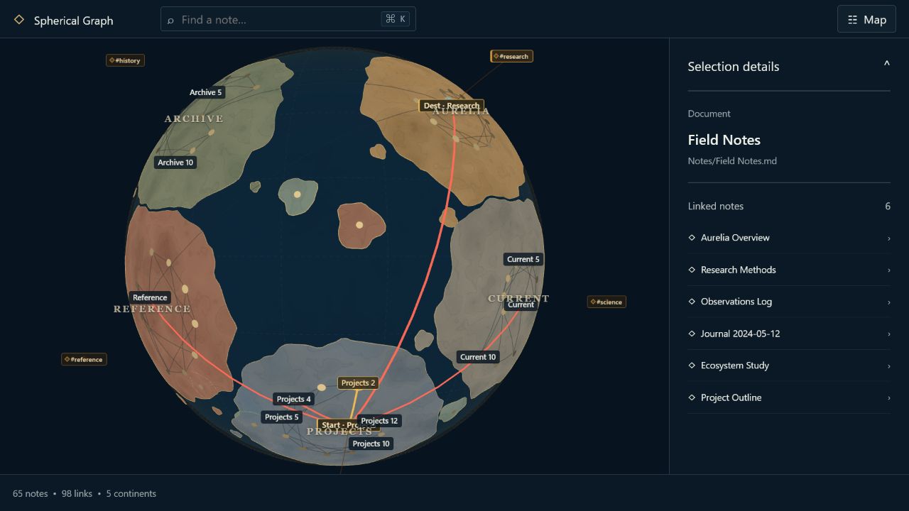
Turn your Obsidian vault into a world you can navigate. Each top-level vault folder becomes its own continent, notes become cities, links become roads across the surface, and tags orbit overhead as satellites. Linked notes stored directly in the vault root become islands; orphan notes remain cities over open water. The cartography reserves approximately half the globe for ocean. A territory-first spherical allocator gives every folder one connected, non-overlapping landmass before cities are relaxed, so even densely cross-linked vaults cannot pull continents into interwoven ribbons. Route Finder reveals every shortest path between distant notes.
Spherical Graph is designed as a stable spatial map: a finite layout operation computes positions, validates and saves one complete snapshot, and then stops. Normal reading, search, filtering, selection, rotation, zoom, theme changes, and resizing do not move notes.
Initialize and Renew first grow deterministic folder territories on an intrinsic icosphere raster. Area quotas follow folder size, simultaneous growth keeps every region connected, and a permanent water buffer separates different owners. Cities are then seeded across their own land with an irregular blue-noise distribution and relaxed without crossing the fixed coast. Sparse graph-distance stress arranges internal roads, while cross-folder links mostly influence macro orientation and relative coastal-port placement. The renderer adds multi-scale shoreline detail and beaches to that committed raster; it no longer invents corridors between cities after layout.
See your vault as a world
Requirements
- Obsidian 1.7.2 or later.
- Desktop, Android phone, or Android tablet. iPhone and iPad use the same mobile profile but still require device testing before they are considered fully supported.
- No account, API key, internet connection, or paid service is required.
Mobile behavior
The globe keeps the same saved layout on desktop and mobile. Automatic mobile profiles reduce GPU pixel density, label budgets, road/land tessellation, and continuous-frame rate without moving a city. While a touch gesture is active, ordinary labels and base roads are temporarily hidden; selections and routes remain visible. Phone mode disables hover, Auto rotate, and the normal atmosphere control. Tablet mode keeps Fullscreen, Auto rotate, and atmosphere.
Touch input supports drag rotation, pinch zoom, and tap selection with a larger tap tolerance. Controls use 44 px targets and safe-area insets. Map controls has a pinned close button, scrolls independently, and stops above Obsidian's bottom navigation. Only one graph view is retained on mobile, rendering stops when Obsidian moves to the background, and an active layout calculation is cancelled to avoid an Android background freeze. Expensive Refresh and Renew actions remain available in the Map controls menu.
Why a sphere?
This is not a conventional 3D force graph with important notes near the center and other notes floating in a volume. Every node is represented internally by a unit vector (u \in S^2), and its rendered point is (R u). The solver uses geodesic angular distance, tangent-plane forces, and exponential-map updates directly on the sphere. Edges are sampled as shortest geodesic arcs on the surface rather than drawn as straight chords through the globe.
The result has no left/right map seam. Notes near longitudes (+180^\circ) and (-180^\circ) are genuinely close because longitude is not a layout coordinate.
Fixed-layout lifecycle
Spherical Graph has three finite layout operations:
- Initialize runs automatically the first time the graph opens without a usable saved layout. The plugin first indexes the current vault, then shows calculation progress until one complete map is validated and saved. Later openings restore that saved map without regenerating it.
- Refresh layout incorporates pending vault changes while preserving the existing mental map. New nodes warm up while old nodes are fixed; then only a local affected set may relax under geodesic anchors and a maximum angular displacement. It is also the explicit way to scan for changes made while Obsidian was closed; when topology is unchanged, metadata is refreshed and no layout operation starts.
- Renew layout is an explicit, confirmed, whole-map regeneration. It uses a new deterministic effective seed and does not use old positions as anchors.
While Refresh or Renew runs, the last committed map remains visible and interactive. Progress messages contain diagnostics only. The renderer receives new coordinates once, after the complete result passes operation-ID, graph signature, length, finiteness, unit-norm, and Refresh-displacement checks. A validated final buffer becomes immutable input to the post-layout geographic analysis before the complete snapshot is saved atomically. A cancelled, stale, invalid, or failed operation leaves the previous snapshot untouched.
Vault changes never start a solver automatically. Instead the view reports a pending state such as:
Changes detected · +7 / -2 notes · 11 link changes
New notes without committed positions remain pending; deleted notes disappear; and a reliable rename keeps the old position under the new path. Select Refresh layout when you want to incorporate the pending graph.
Features
- Dedicated
Spherical GraphItemView, ribbon action, and command-palette commands. - Intrinsic, seam-free spherical layout with deterministic exact and sampled repulsion modes.
- Territory-first Initialize/Renew placement directly on (S^2): every non-orphan top-level folder receives a connected irregular raster region, different owners remain separated by sea, and approximately 52% of the surface remains ocean.
- Cities use deterministic farthest-point/blue-noise seeding across their territory. Internal links retain full spring weight; cross-folder links are reduced to a weak macro/port influence and cannot manufacture land arms.
- Bounded graph-distance landmark stress breaks hub rings, while a final marker-aware S² collision projection prevents visible node overlap without moving hard-fixed Refresh nodes.
- Relatively strong, directionally coherent inter-continent endpoints become port cities and can reach the coastline on the side of their strongest roads.
- Post-layout cartography consumes the committed owner raster directly and only adds sub-cell coast detail, relief, beaches, and root-note islands.
- Degree-zero notes stay as cities over water. Degree-one/two folder notes remain on their continent; only linked root notes receive island patches.
- Membership matching preserves stable continent identity and color across compatible Refreshes and multi-note top-level folder renames.
- Incremental Refresh with a new-node warm-up, graph-neighborhood affected set, hard-fixed remote nodes, anchors, and a displacement cap.
- Transactional committed snapshot, schema migrations, stable camera state,
saved graph metadata, exact continent territory raster, tags, auxiliary nodes, pins, and safe
rename/prune handling. The complete
data.jsonmap can be carried by Obsidian Sync and restored with Load map. When the optional derived graph cache is compacted for Sync safety, the vault is indexed again while the canonical layout and geography remain unchanged. - Short-lived inline Web Workers isolate layout solving, live-vault graph indexing, post-layout continental analysis, and detailed land meshing from Obsidian's UI thread. Large maps use an adaptive land-detail ceiling.
- Three.js rendering with a matte ocean, batched topology-derived land, deterministic organic coastlines supported by actual member cities and short internal roads, an irregular sand beach band, sea carved by neighboring regions, islands, cartographic region labels, instanced tangent city markers, batched geodesic roads, a restrained dashed graticule, smoothly fading labels, responsive narrow-pane framing, and invalidation-based frames.
- Hover details, selection, linked-neighbor and same-subfolder emphasis, active-note emphasis, search/focus, open-note actions, camera reset, keyboard controls, and a translucent selection panel with clickable direct neighbors.
- A persistent Auto rotate switch in the bottom rail starts or stops a slow camera orbit. Manual camera interaction pauses it and resumes it three seconds after the last adjustment without clearing the switch.
- A procedural cloud atmosphere appears only at wider zoom levels while Auto rotate is enabled. The cloud-only shell has an irregular limb, rotates once every ten minutes relative to the globe, and can be hidden independently.
- Persistent map pins mark favourite note cities. Pins, the committed layout, camera, and settings share one versioned plugin-data envelope with automatic and explicit Save map persistence.
- A control-free Fullscreen presentation mode forces atmosphere and Auto rotate on temporarily, then restores the previous rotation state on exit.
- Searchable excluded-folder picker in settings. Selecting a folder excludes its entire subtree after an explicit Refresh without moving the current map immediately.
- Offline route finding that highlights every shortest path between two notes
over the existing links, including all equally short alternatives, explicit
StartandDestmarkers, and clickable route details. - Intrinsically packed, polished-silver tag satellites on an adjustable, invisible concentric orbit. Their size and contrast recede with perspective, and their positions are anchored to the final locations of the notes that carry them. Thin silver spherical spirals connect tags to the selected note, every note in the active shortest-path union, or every note carrying a selected tag. Satellites and link segments hidden behind the globe are culled geometrically.
- Configurable zoom thresholds independently reveal labels and roads only when the camera is close enough, reducing clutter in large vaults.
- Solid, transparent, and hidden sphere-surface modes.
- Render-only visibility filters for tags, attachments, unresolved links, and orphan notes. Filters hide markers and incident links without moving the map.
- Theme-aware colors, resize handling, pop-out owner-window awareness, and explicit resource cleanup.
- No telemetry, runtime network calls, external keys, or note-content writes.
Controls
| Action | Control |
|---|---|
| Rotate | Drag empty canvas space |
| Rotate on touch | Drag with one finger |
| Zoom on touch | Pinch with two fingers |
| Start or stop automatic rotation | Toggle Auto rotate in the bottom status rail |
| Zoom | Wheel or supported pinch gesture |
| Inspect | Hover a node |
| Select | Click a node |
| Pin or unpin a favourite city | Select a note, then use Pin note / Unpin note in Selection details |
| Select a tag and show its links | Click a silver tag satellite |
| Clear selection | Click empty canvas space or press Escape |
| Open note | Double-click a node or press Enter on a selected search result |
| Open in new tab | Ctrl/Cmd + click |
| Open from selection details | Click a selected, linked, endpoint, or route note; hold Ctrl/Cmd for a new tab |
| Hide or show selection details | Select the Selection details header |
| Find and focus | Type in Find a note or tag… and choose a result |
| Find all shortest routes | Select an origin, then choose Map controls → Explore → Find route and select a destination |
| Clear a route | Choose the active route control in Map controls → Explore |
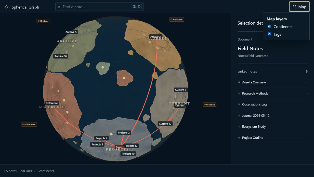
| Hide categories without moving the map | Use Map controls → Visible content |
| Hide or show geography | Toggle Continents in Map controls → Globe |
| Hide or show the cloud layer | Toggle Atmosphere in Map controls → Globe |
| Save the complete map state now | Choose Map controls → Saved map → Save map |
| Reload the last saved or synced map | Choose Map controls → Saved map → Load map |
| Enter the control-free presentation globe | Choose Map controls → Explore → Fullscreen; use Exit fullscreen or press Escape to return |
| Change globe surface | Use Map controls → Globe |
| Include pending changes | Choose Map controls → Layout → Refresh layout |
| Build a new world | Choose Map controls → Layout → Renew layout, then confirm |
| Stop a calculation | Choose Map controls → Layout → Cancel calculation |
| Restore view | Choose Map controls → Explore → Reset camera |
Manual or automatic rotation changes only the camera and never a node position.
Settings
Data
- searchable excluded-folder picker with subtree semantics and removable paths
- graph-change debounce
- pending-diff detail limit
Appearance
- separate Phone render quality and Tablet render quality profiles: Automatic (recommended), Battery saver, and High quality; reopen the graph view after changing a profile
- relative Globe size and degree scaling; a larger Globe value makes city markers and the coral selection frame smaller without moving the layout. Initialize and Renew automatically choose this value from the vault's note count; Refresh preserves the current value
- tag-orbit height as a percentage of the globe radius (one third by default), plus an optional camera-axis protection guard, disabled by default
- edge opacity and an independent zoom-in visibility threshold (50% by default)
- labels, maximum pooled labels, and a zoom-in threshold (80% by default); note and tag labels fade and scale smoothly around that threshold
- continent, coastline, island, cartographic-label, and atmosphere visibility; atmosphere height is expressed as a percentage of the globe radius
- sphere surface mode and opacity
- theme-following background
- focus-animation duration
Layout
- deterministic base seed
- spring, repulsion, centroid, and isotropy strengths
- damping, step, angular-speed cap, convergence, and iteration budget
- exact-repulsion threshold and sampled negative count
- progress-report interval
Refresh preservation
- new-node warm-up budget
- affected graph-neighborhood depth
- anchor strength and directly affected multiplier
- maximum old-node angular displacement
- large-change warning ratio
Visual settings apply without running a solver. The graph-menu filters for tags, attachments, unresolved links, and orphan notes are also render-only. Data exclusions can create pending changes. Layout settings apply to the next relevant explicit operation; changing them alone does not move the current map.
Saving and Obsidian Sync
Completed layouts are saved automatically. Settings are debounced and pin changes are committed immediately. Camera movement stays device-local until Map controls → Saved map → Save map stores the current viewpoint together with the complete layout, settings, and pins. Avoiding background camera writes also prevents an inactive device from rolling a newer synchronized map back.
The only authoritative state file is Obsidian's standard
.obsidian/plugins/spherical-graph/data.json. To carry the same layout and
pins between devices, enable community-plugin data in
Obsidian Sync settings for the vault.
No extra file is written into the vault root. If Sync updates plugin data while
Obsidian is already running, choose Load map after Sync finishes; the
command re-reads data.json, invalidates any older local graph scan, and
restores the synchronized positions, continents, camera, and pins as one map.
Partial settings, cache, or pin writes first preserve newer fields already
delivered by Sync.
To stay below the 5 MB per-file ceiling of the Standard Sync plan, persistence uses a 4.5 MB safety budget. At the budget boundary it discards only the rebuildable graph cache; committed positions, continent ownership, camera, settings, and pins remain authoritative. If those canonical fields alone exceed the budget, the save is rejected instead of writing an unsyncable or partial state.
Installation
After publication, install Spherical Graph from Settings → Community plugins → Browse.
For a manual or beta installation:
-
Build the plugin or download a release.
-
Place these files directly in
<vault>/.obsidian/plugins/spherical-graph/:main.jsmanifest.jsonstyles.css
-
Restart or reload Obsidian after the first install or an ID/manifest change.
-
Open Settings → Community plugins, enable Spherical Graph, and run Spherical Graph: Open graph from the command palette.
Do not create an extra nested repository directory; manifest.json must be
directly inside .obsidian/plugins/spherical-graph/.
Development
Use a dedicated disposable development vault.
npm ci
npm run dev
Quality and utility commands:
npm run lint
npm run typecheck
npm run test
npm run test:coverage
npm run build
npm run validate:release
npm run check
npm run benchmark:layout
npm run generate:test-vault -- --output ./tmp/test-vault --nodes 500 --edges 1500 --seed 42 --pattern clustered

# Stress continent allocation with many root folders and cross-folder roads
npm run generate:test-vault -- --output ./tmp/territory-vault --nodes 480 --edges 2800 --seed 20260805 --pattern territories --folders 24
The production build writes the release artifacts to the repository root. The
layout worker source is embedded into main.js; no separate worker file is
required.
See ARCHITECTURE.md, ALGORITHM.md, MANUAL_TEST_PLAN.md, and VALIDATION.md. The complete implementation specification is preserved in docs/CODEX_TASK.md.
Privacy and safety
Spherical Graph is designed for private, offline vault use:
- It reads Markdown file metadata, tags, and Obsidian's resolved-link index.
- It never modifies note contents and never accesses files outside the vault.
- It stores plugin settings, vault-relative note paths, normalized layout positions, graph descriptors, post-layout continent membership, diagnostic centers/extents, camera state, and pinned-note paths through Obsidian's plugin-data API. Tag satellites, atmosphere clouds, and analytical spherical-grid cells are derived at runtime and are not persisted.
- It performs no runtime network requests, telemetry, remote-code loading, advertising, or automatic plugin updates.
- It requires no account, payment, external key, or remote service.
Support and security
- Report bugs and request features through GitHub Issues.
- Follow CONTRIBUTING.md before submitting a change.
- Report security problems using the private process in SECURITY.md, not a public issue.
Known limitations
- Android uses adaptive phone/tablet profiles, but final release QA is still required on representative low-memory phones and tablets. Very large vaults are intentionally outside the phone use case and must fail gracefully.
- Arbitrary non-planar graphs can still have crossing edges on a sphere.
- Labels are intentionally capped and fade with zoom, so not every visible note is labelled at every camera distance. Narrow panes can lower the on-screen label budget further without changing the configured maximum.
- Every tag has an instanced satellite marker, while visible tag text labels are capped at 96. Tags behind the globe are hidden; optional camera-axis fading can additionally protect the center of the view.
- Route highlighting shows the union of all shortest paths. When alternatives overlap, their shared sections are intentionally drawn once.
- Very large graphs use deterministic sampled global repulsion; this is an approximation rather than exact all-pairs force evaluation.
- The plugin stores one committed layout snapshot and has no layout undo history, edge bundling, overlapping/fuzzy continent membership, manual country editing, ghost nodes, or image export.
- Actual GUI verification performed for a release is recorded in VALIDATION.md; automated checks do not imply a manual GUI pass.
Release
- Run
npm ciandnpm run checkfrom a clean checkout. - Update
manifest.json,package.json,versions.json, and CHANGELOG.md. - Push a tag exactly equal to the manifest version, without a leading
v. The release workflow repeats the full check, verifies the tag/version, attests the build, and creates a draft release containingmain.js,manifest.json, andstyles.css. - Review and publish the draft GitHub release.
- For the first directory submission, make the repository public, link GitHub at community.obsidian.md, choose Plugins → New plugin, and submit the repository URL.
The complete maintainer procedure is in docs/RELEASE_CHECKLIST.md.
License
MIT. Third-party attributions are in THIRD_PARTY_NOTICES.md.
For plugin developers
Search results and similarity scores are powered by semantic analysis of your plugin's README. If your plugin isn't appearing for searches you'd expect, try updating your README to clearly describe your plugin's purpose, features, and use cases.